function createMarker(idx, latlng, name, html, category) {
var contentString = html;
var marker = new google.maps.Marker({
position: latlng,
icon: getMarkerImage(category),
map: map,
title: name,
});
marker.mycategory = category;
marker.myname = name;
gmarkers.push(marker);
google.maps.event.addListener(marker, 'click', function() {
infowindow.setContent(contentString);
infowindow.open(map,marker);
highlight(idx);
});
}
function highlight(a)
{ if(lastClick!=undefined && lastClick!=-1)
document.getElementById('click'+lastClick).style.background = "none";
document.getElementById('click'+a).style.background = "#FFCC00";
lastClick = a;
}
function findMarker(i) {
google.maps.event.trigger(gmarkers[i],"click");
}
function getMarkerImage(category) {
if(!gicons[category]) {
gicons[category] = new google.maps.MarkerImage("icons/"+category+".png",
new google.maps.Size(30,30),
new google.maps.Point(0,0),
new google.maps.Point(0,15));
}
return gicons[category];
}
var map = null;
var gmarkers = [];
var gicons = [];
var lastClick = -1;
var infowindow = new google.maps.InfoWindow({
size: new google.maps.Size(150,50)
});
var markers = new Array();
var infos = new Array();
var infowindows = new Array();
function initialize() {
map = new google.maps.Map(
document.getElementById('map'), {
center: new google.maps.LatLng(-13.22, -72.393),
zoom: 14,
mapTypeId: google.maps.MapTypeId.SATELLITE
});
google.maps.event.addListener(map, 'click', function() {
infowindow.close();
});
document.getElementById('sidecontent').innerHTML = "Loading data...";
var ppoints=[new google.maps.LatLng(-13.215203,-72.382191),new google.maps.LatLng(-13.215726,-72.383032),new google.maps.LatLng(-13.215877,-72.383788),new google.maps.LatLng(-13.216300,-72.383710),new google.maps.LatLng(-13.220196,-72.388214),new google.maps.LatLng(-13.222896,-72.390451),new google.maps.LatLng(-13.223736,-72.393786),new google.maps.LatLng(-13.225177,-72.396141),new google.maps.LatLng(-13.226441,-72.397649),new google.maps.LatLng(-13.227308,-72.398759),new google.maps.LatLng(-13.229010,-72.402611),new google.maps.LatLng(-13.230499,-72.403131),new google.maps.LatLng(-13.231622,-72.403985),new google.maps.LatLng(-13.231470,-72.406221),new google.maps.LatLng(-13.232869,-72.408394),new google.maps.LatLng(-13.233548,-72.410985),new google.maps.LatLng(-13.232732,-72.413635),new google.maps.LatLng(-13.232583,-72.414231),new google.maps.LatLng(-13.233069,-72.415905),new google.maps.LatLng(-13.233225,-72.416253),new google.maps.LatLng(-13.231700,-72.417000),new google.maps.LatLng(-13.231700,-72.417000),new google.maps.LatLng(-13.233590,-72.416790),new google.maps.LatLng(-13.234019,-72.417182),new google.maps.LatLng(-13.234782,-72.417391),new google.maps.LatLng(-13.235737,-72.418780),new google.maps.LatLng(-13.237090,-72.419070),new google.maps.LatLng(-13.236406,-72.419864),new google.maps.LatLng(-13.235774,-72.420009),new google.maps.LatLng(-13.235299,-72.420572),new google.maps.LatLng(-13.234870,-72.421473),new google.maps.LatLng(-13.235079,-72.422235),new google.maps.LatLng(-13.235366,-72.422680),new google.maps.LatLng(-13.235956,-72.422846),new google.maps.LatLng(-13.236254,-72.423522),new google.maps.LatLng(-13.236348,-72.424515),new google.maps.LatLng(-13.236019,-72.424971),new google.maps.LatLng(-13.235946,-72.425325),new google.maps.LatLng(-13.236421,-72.425518),new google.maps.LatLng(-13.238672,-72.425872),new google.maps.LatLng(-13.239935,-72.426896),new google.maps.LatLng(-13.240839,-72.427041),new google.maps.LatLng(-13.241575,-72.427406),new google.maps.LatLng(-13.242479,-72.427626),new google.maps.LatLng(-13.243262,-72.428012),new google.maps.LatLng(-13.244233,-72.428222),new google.maps.LatLng(-13.244865,-72.428767),new google.maps.LatLng(-13.245591,-72.429595),new google.maps.LatLng(-13.246452,-72.430008),new google.maps.LatLng(-13.247241,-72.431049),new google.maps.LatLng(-13.248096,-72.433054),new google.maps.LatLng(-13.248374,-72.433205),new google.maps.LatLng(-13.249914,-72.435625),new google.maps.LatLng(-13.251345,-72.437652),new google.maps.LatLng(-13.253098,-72.439835),new google.maps.LatLng(-13.254147,-72.441316),new google.maps.LatLng(-13.255327,-72.441723),new google.maps.LatLng(-13.256144,-72.442191),new google.maps.LatLng(-13.256426,-72.442598),new google.maps.LatLng(-13.257841,-72.443269),new google.maps.LatLng(-13.261185,-72.445199),new google.maps.LatLng(-13.263882,-72.446686),new google.maps.LatLng(-13.264430,-72.447593),new google.maps.LatLng(-13.264428,-72.448168),new google.maps.LatLng(-13.264428,-72.448168),new google.maps.LatLng(-13.264428,-72.448168),new google.maps.LatLng(-13.264428,-72.448168),new google.maps.LatLng(-13.264428,-72.448168),new google.maps.LatLng(-13.264428,-72.448168),new google.maps.LatLng(-13.264472,-72.448628),new google.maps.LatLng(-13.264007,-72.450135),new google.maps.LatLng(-13.262576,-72.452249),new google.maps.LatLng(-13.262153,-72.453697),new google.maps.LatLng(-13.261861,-72.454062),new google.maps.LatLng(-13.261391,-72.454808),new google.maps.LatLng(-13.260707,-72.456615),new google.maps.LatLng(-13.260053,-72.458149),new google.maps.LatLng(-13.260321,-72.459400),new google.maps.LatLng(-13.260420,-72.460049),new google.maps.LatLng(-13.260284,-72.460698),new google.maps.LatLng(-13.260560,-72.461539),new google.maps.LatLng(-13.260310,-72.461991),new google.maps.LatLng(-13.259704,-72.461615),new google.maps.LatLng(-13.259254,-72.461743),new google.maps.LatLng(-13.258723,-72.461476),new google.maps.LatLng(-13.257867,-72.461266),new google.maps.LatLng(-13.257495,-72.462215),new google.maps.LatLng(-13.256321,-72.463364),new google.maps.LatLng(-13.255956,-72.464115),new google.maps.LatLng(-13.255627,-72.464254),new google.maps.LatLng(-13.255245,-72.464807),new google.maps.LatLng(-13.255157,-72.465370),new google.maps.LatLng(-13.254948,-72.465971),new google.maps.LatLng(-13.254838,-72.466599),new google.maps.LatLng(-13.254076,-72.467586),new google.maps.LatLng(-13.253616,-72.468101),new google.maps.LatLng(-13.253214,-72.468465),new google.maps.LatLng(-13.252755,-72.468841),new google.maps.LatLng(-13.252468,-72.469281),new google.maps.LatLng(-13.252123,-72.469587),new google.maps.LatLng(-13.251799,-72.470118),new google.maps.LatLng(-13.251366,-72.471185),new google.maps.LatLng(-13.250546,-72.471850),new google.maps.LatLng(-13.249867,-72.472328),new google.maps.LatLng(-13.249309,-72.473031),new google.maps.LatLng(-13.248049,-72.474709),new google.maps.LatLng(-13.247934,-72.476087),new google.maps.LatLng(-13.247955,-72.477994),new google.maps.LatLng(-13.246133,-72.479317),new google.maps.LatLng(-13.245424,-72.480605),new google.maps.LatLng(-13.244129,-72.482349),new google.maps.LatLng(-13.242770,-72.484424),new google.maps.LatLng(-13.242280,-72.484231),new google.maps.LatLng(-13.241565,-72.485379),new google.maps.LatLng(-13.240975,-72.486002),new google.maps.LatLng(-13.240996,-72.486608),new google.maps.LatLng(-13.240938,-72.488850),new google.maps.LatLng(-13.238876,-72.491581),new google.maps.LatLng(-13.237977,-72.492450),new google.maps.LatLng(-13.237674,-72.492841),new google.maps.LatLng(-13.237246,-72.493469),new google.maps.LatLng(-13.236970,-72.493963),new google.maps.LatLng(-13.236552,-72.495636),new google.maps.LatLng(-13.236514,-72.496311),new google.maps.LatLng(-13.235419,-72.496929),new google.maps.LatLng(-13.234782,-72.497707),new google.maps.LatLng(-13.234254,-72.498007),new google.maps.LatLng(-13.233706,-72.498057),new google.maps.LatLng(-13.233706,-72.498057),new google.maps.LatLng(-13.233706,-72.498057),new google.maps.LatLng(-13.233706,-72.498057),new google.maps.LatLng(-13.233706,-72.498057),new google.maps.LatLng(-13.233706,-72.498057),new google.maps.LatLng(-13.233706,-72.498057),new google.maps.LatLng(-13.233706,-72.498057),new google.maps.LatLng(-13.233596,-72.498538),new google.maps.LatLng(-13.233069,-72.498914),new google.maps.LatLng(-13.232219,-72.499338),new google.maps.LatLng(-13.230624,-72.499938),new google.maps.LatLng(-13.230243,-72.500699),new google.maps.LatLng(-13.229861,-72.500823),new google.maps.LatLng(-13.228822,-72.501456),new google.maps.LatLng(-13.228599,-72.501553),new google.maps.LatLng(-13.228437,-72.501703),new google.maps.LatLng(-13.228254,-72.501929),new google.maps.LatLng(-13.227993,-72.502299),new google.maps.LatLng(-13.227580,-72.502508),new google.maps.LatLng(-13.227794,-72.502856),new google.maps.LatLng(-13.227424,-72.503479),new google.maps.LatLng(-13.226849,-72.504187),new google.maps.LatLng(-13.226630,-72.504788),new google.maps.LatLng(-13.226828,-72.505442),new google.maps.LatLng(-13.226849,-72.506016),new google.maps.LatLng(-13.226996,-72.506472),new google.maps.LatLng(-13.226285,-72.507787),new google.maps.LatLng(-13.226019,-72.508586),new google.maps.LatLng(-13.226103,-72.509396),new google.maps.LatLng(-13.226014,-72.510303),new google.maps.LatLng(-13.226002,-72.511380),new google.maps.LatLng(-13.227445,-72.514809),new google.maps.LatLng(-13.227836,-72.515544),new google.maps.LatLng(-13.227962,-72.515946),new google.maps.LatLng(-13.227445,-72.515549),new google.maps.LatLng(-13.226990,-72.515345),new google.maps.LatLng(-13.226729,-72.515576),new google.maps.LatLng(-13.226656,-72.515919),new google.maps.LatLng(-13.226311,-72.516161),new google.maps.LatLng(-13.225633,-72.516922),new google.maps.LatLng(-13.223655,-72.518563),new google.maps.LatLng(-13.222900,-72.519100),new google.maps.LatLng(-13.222900,-72.519100),new google.maps.LatLng(-13.222900,-72.519100),new google.maps.LatLng(-13.222110,-72.519615),new google.maps.LatLng(-13.221465,-72.519905),new google.maps.LatLng(-13.220818,-72.520034),new google.maps.LatLng(-13.220457,-72.520924),new google.maps.LatLng(-13.220431,-72.521396),new google.maps.LatLng(-13.219883,-72.521868),new google.maps.LatLng(-13.219637,-72.522491),new google.maps.LatLng(-13.218974,-72.522887),new google.maps.LatLng(-13.218583,-72.523606),new google.maps.LatLng(-13.218013,-72.524298),new google.maps.LatLng(-13.217935,-72.524808),new google.maps.LatLng(-13.217804,-72.525602),new google.maps.LatLng(-13.217141,-72.525339),new google.maps.LatLng(-13.216593,-72.525505),new google.maps.LatLng(-13.216358,-72.525044),new google.maps.LatLng(-13.216100,-72.524400),new google.maps.LatLng(-13.215898,-72.524196),new google.maps.LatLng(-13.215731,-72.523402),new google.maps.LatLng(-13.215162,-72.523129),new google.maps.LatLng(-13.214598,-72.523166),new google.maps.LatLng(-13.213799,-72.523193),new google.maps.LatLng(-13.212660,-72.524035),new google.maps.LatLng(-13.211611,-72.525076),new google.maps.LatLng(-13.210848,-72.526230),new google.maps.LatLng(-13.210242,-72.527136),new google.maps.LatLng(-13.209130,-72.527640),new google.maps.LatLng(-13.208791,-72.528729),new google.maps.LatLng(-13.207798,-72.529931),new google.maps.LatLng(-13.207480,-72.531036),new google.maps.LatLng(-13.206890,-72.530500),new google.maps.LatLng(-13.206994,-72.530961),new google.maps.LatLng(-13.206822,-72.531342),new google.maps.LatLng(-13.207010,-72.531492),new google.maps.LatLng(-13.206994,-72.532136),new google.maps.LatLng(-13.206226,-72.532570),new google.maps.LatLng(-13.205965,-72.532822),new google.maps.LatLng(-13.204962,-72.532619),new google.maps.LatLng(-13.204466,-72.532940),new google.maps.LatLng(-13.204148,-72.533032),new google.maps.LatLng(-13.203824,-72.533316),new google.maps.LatLng(-13.203098,-72.534367),new google.maps.LatLng(-13.202727,-72.535322),new google.maps.LatLng(-13.202534,-72.536020),new google.maps.LatLng(-13.202236,-72.536583),new google.maps.LatLng(-13.202320,-72.537463),new google.maps.LatLng(-13.201800,-72.538300),new google.maps.LatLng(-13.201907,-72.538401),new google.maps.LatLng(-13.201620,-72.538482),new google.maps.LatLng(-13.201160,-72.539367),new google.maps.LatLng(-13.200440,-72.539490),new google.maps.LatLng(-13.199484,-72.539721),new google.maps.LatLng(-13.199238,-72.540123),new google.maps.LatLng(-13.198497,-72.540097),new google.maps.LatLng(-13.198105,-72.540445),new google.maps.LatLng(-13.197463,-72.540622),new google.maps.LatLng(-13.195901,-72.540612),new google.maps.LatLng(-13.195081,-72.540654),new google.maps.LatLng(-13.194451,-72.540815),new google.maps.LatLng(-13.193890,-72.540880),new google.maps.LatLng(-13.193410,-72.541245),new google.maps.LatLng(-13.192825,-72.541529),new google.maps.LatLng(-13.192391,-72.541507),new google.maps.LatLng(-13.191848,-72.541320),new google.maps.LatLng(-13.191472,-72.541046),new google.maps.LatLng(-13.191650,-72.540622),new google.maps.LatLng(-13.191300,-72.540799),new google.maps.LatLng(-13.191592,-72.540080),new google.maps.LatLng(-13.191211,-72.540306),new google.maps.LatLng(-13.191342,-72.539866),new google.maps.LatLng(-13.190919,-72.539823),new google.maps.LatLng(-13.191060,-72.539104),new google.maps.LatLng(-13.190793,-72.539104),new google.maps.LatLng(-13.190652,-72.538396),new google.maps.LatLng(-13.190587,-72.538171),new google.maps.LatLng(-13.190506,-72.537817),new google.maps.LatLng(-13.190203,-72.537431),new google.maps.LatLng(-13.190203,-72.537431),new google.maps.LatLng(-13.190203,-72.537431),new google.maps.LatLng(-13.190203,-72.537431),new google.maps.LatLng(-13.190203,-72.537431),new google.maps.LatLng(-13.190203,-72.537431),new google.maps.LatLng(-13.189843,-72.537141),new google.maps.LatLng(-13.189529,-72.537532),new google.maps.LatLng(-13.189174,-72.538106),new google.maps.LatLng(-13.188500,-72.538616),new google.maps.LatLng(-13.186944,-72.538627),new google.maps.LatLng(-13.186385,-72.539222),new google.maps.LatLng(-13.185105,-72.539104),new google.maps.LatLng(-13.183894,-72.539506),new google.maps.LatLng(-13.182661,-72.540257),new google.maps.LatLng(-13.182515,-72.540687),new google.maps.LatLng(-13.180948,-72.541438),new google.maps.LatLng(-13.180128,-72.541765),new google.maps.LatLng(-13.179590,-72.541824),new google.maps.LatLng(-13.178592,-72.539356),new google.maps.LatLng(-13.177972,-72.537940),new google.maps.LatLng(-13.177130,-72.537409),new google.maps.LatLng(-13.176827,-72.536808),new google.maps.LatLng(-13.176341,-72.536685),new google.maps.LatLng(-13.175829,-72.536529),new google.maps.LatLng(-13.174800,-72.536148),new google.maps.LatLng(-13.174001,-72.535381),new google.maps.LatLng(-13.173385,-72.534271),new google.maps.LatLng(-13.173087,-72.533836),new google.maps.LatLng(-13.172554,-72.533976),new google.maps.LatLng(-13.172074,-72.534475),new google.maps.LatLng(-13.170209,-72.534861),new google.maps.LatLng(-13.170209,-72.534861),new google.maps.LatLng(-13.171264,-72.539099),new google.maps.LatLng(-13.170470,-72.541931),new google.maps.LatLng(-13.169206,-72.542843),new google.maps.LatLng(-13.168590,-72.543905),new google.maps.LatLng(-13.167822,-72.544330),new google.maps.LatLng(-13.167206,-72.544667),new google.maps.LatLng(-13.166694,-72.544871),new google.maps.LatLng(-13.166051,-72.545161),new google.maps.LatLng(-13.165508,-72.545466),new google.maps.LatLng(-13.164634,-72.545576),]; var path = new google.maps.Polyline({
path: ppoints,
geodesic: true,
strokeColor: '#00FF00',
strokeOpacity: 0.5,
strokeWeight: 6
});
path.setMap(map);
tooltip = "Altitude: 8799 ft (2682 m)
The Inca Trail stars here. It is km 82 but for the trek it is considered as km 0.
Altitude: 8799 ft (2682 m)
The Inca Trail stars here. It is km 82 but for the trek it is considered as km 0.
";
var category = 'start';
var marker = createMarker(0, point, name, html, category);
tooltip = "Stairs
Altitude: 8766 ft (2672 m)
Stairs
Altitude: 8766 ft (2672 m)
";
var category = 'stairs';
var marker = createMarker(1, point, name, html, category);
tooltip = "Salapunku
This is the first archaeological inca site seen during the Trek. It is located at the right bank of the Urubamba river.
Salapunku
This is the first archaeological inca site seen during the Trek. It is located at the right bank of the Urubamba river.
";
var category = 'ruin';
var marker = createMarker(2, point, name, html, category);
tooltip = "Q'hanamarca
Archaeological inca site.
Q'hanamarca
Archaeological inca site.
";
var category = 'ruin';
var marker = createMarker(3, point, name, html, category);
tooltip = "Ñustajispana
This site is decently called sometimes Ñustahispana that, in quechua, means the Spanish princess; but its real name means the princess that urinates, to remember that even the nobility was constitued by human beings.
Ñustajispana
This site is decently called sometimes Ñustahispana that, in quechua, means the Spanish princess; but its real name means the princess that urinates, to remember that even the nobility was constitued by human beings.
";
var category = 'ruin';
var marker = createMarker(4, point, name, html, category);
tooltip = "Llaqtapata
Altitude: 9022 ft (2750 m)
In the km 3, will discover Llaqtapata which, in quechua, means the town on hillside. These ruins, constitued by a village and farming terraces, are located on the banks of the Cusichaca River.
Llaqtapata
Altitude: 9022 ft (2750 m)
In the km 3, will discover Llaqtapata which, in quechua, means the town on hillside. These ruins, constitued by a village and farming terraces, are located on the banks of the Cusichaca River.
";
var category = 'ruin';
var marker = createMarker(5, point, name, html, category);
tooltip = "Qoriwayrachina
Altitude: 8202 ft (2500 m)
Railway station at km 88. It is another departure point of the Inca Trail.
Qoriwayrachina
Altitude: 8202 ft (2500 m)
Railway station at km 88. It is another departure point of the Inca Trail.
";
var category = 'train';
var marker = createMarker(6, point, name, html, category);
tooltip = "Qoriwayrachina
Altitude: 8202 ft (2500 m)
Bridge in Qoriwayrachina, at km 88, crossing the Urubamba river.
Qoriwayrachina
Altitude: 8202 ft (2500 m)
Bridge in Qoriwayrachina, at km 88, crossing the Urubamba river.
";
var category = 'point';
var marker = createMarker(7, point, name, html, category);
tooltip = "Miskay
Altitude: 8727 ft (2660 m)
Archaeological inca site.
Miskay
Altitude: 8727 ft (2660 m)
Archaeological inca site.
";
var category = 'ruin';
var marker = createMarker(8, point, name, html, category);
tooltip = "Miskay
Altitude: 8727 ft (2660 m)
Lunch at Miskay
Miskay
Altitude: 8727 ft (2660 m)
Lunch at Miskay
";
var category = 'meal';
var marker = createMarker(9, point, name, html, category);
tooltip = "Willkarakay
Archaeological inca site.
Willkarakay
Archaeological inca site.
";
var category = 'ruin';
var marker = createMarker(10, point, name, html, category);
tooltip = "Ruines
Archaeological inca site.
Ruines
Archaeological inca site.
";
var category = 'ruin';
var marker = createMarker(11, point, name, html, category);
tooltip = "Tablachaka
Altitude: 9186 ft (2800 m)
Tablachaka
Altitude: 9186 ft (2800 m)
";
var category = 'point';
var marker = createMarker(12, point, name, html, category);
tooltip = "Urkapata
Archaeological inca site.
Urkapata
Archaeological inca site.
";
var category = 'ruin';
var marker = createMarker(13, point, name, html, category);
tooltip = "First Night Camp out
Altitude: 11122 ft (3390 m)
It's the Wayllabamba camp.
First Night Camp out
Altitude: 11122 ft (3390 m)
It's the Wayllabamba camp.
";
var category = 'camp';
var marker = createMarker(14, point, name, html, category);
tooltip = "";
var point = new google.maps.LatLng(-13.2639,-72.4488);
var name = "Stairs in Wayllabamba";
var html = "Stairs in Wayllabamba
";
var category = 'stairs';
var marker = createMarker(15, point, name, html, category);
tooltip = "Yuncachimpa
Altitude: 10696 ft (3260 m)
The Yuncachimpa camp is often used to spend the first night.
Yuncachimpa
Altitude: 10696 ft (3260 m)
The Yuncachimpa camp is often used to spend the first night.
";
var category = 'camp';
var marker = createMarker(16, point, name, html, category);
tooltip = "Paucarcancha
Altitude: 10515 ft (3205 m)
Archaeological inca site, located at the confluence of the Pampacahua and Keska valleys.
Paucarcancha
Altitude: 10515 ft (3205 m)
Archaeological inca site, located at the confluence of the Pampacahua and Keska valleys.
";
var category = 'ruin';
var marker = createMarker(17, point, name, html, category);
tooltip = "Coralpunku
Altitude: 12139 ft (3700 m)
Coralpunku
Altitude: 12139 ft (3700 m)
";
var category = 'camp';
var marker = createMarker(18, point, name, html, category);
tooltip = "Llulluchapampa
Altitude: 12467 ft (3800 m)
Llulluchapampa
Altitude: 12467 ft (3800 m)
";
var category = 'camp';
var marker = createMarker(19, point, name, html, category);
tooltip = "Warmiwañusca
Altitude: 13858 ft (4224 m)
This is the highest point in the Inca Trail. It's not rare that it snows there and, after passing this point, weather and vegetation correspond to the high forest of Cusco.
Warmiwañusca
Altitude: 13858 ft (4224 m)
This is the highest point in the Inca Trail. It's not rare that it snows there and, after passing this point, weather and vegetation correspond to the high forest of Cusco.
";
var category = 'point';
var marker = createMarker(20, point, name, html, category);
tooltip = "Stairs
Altitude: 12008 ft (3660 m)
Stairs
Altitude: 12008 ft (3660 m)
";
var category = 'stairs';
var marker = createMarker(21, point, name, html, category);
tooltip = "2nd Night Campsite
Altitude: 11952 ft (3643 m)
It's the Pacamayo camp, located at the bottom of the valley, where you will spend the second night.
2nd Night Campsite
Altitude: 11952 ft (3643 m)
It's the Pacamayo camp, located at the bottom of the valley, where you will spend the second night.
";
var category = 'camp';
var marker = createMarker(22, point, name, html, category);
tooltip = "Laguna Saqtaycocha
Altitude: 13976 ft (4260 m)
Magnificent lagoon, with resident ducks and geese.
Laguna Saqtaycocha
Altitude: 13976 ft (4260 m)
Magnificent lagoon, with resident ducks and geese.
";
var category = 'water';
var marker = createMarker(23, point, name, html, category);
tooltip = "Runkuraqay Tambo
Altitude: 12874 ft (3924 m)
At the km 24, in the Pacaymayo valley, is located Tambo Inca, a semi-circular ovoidal building.
Runkuraqay Tambo
Altitude: 12874 ft (3924 m)
At the km 24, in the Pacaymayo valley, is located Tambo Inca, a semi-circular ovoidal building.
";
var category = 'ruin';
var marker = createMarker(24, point, name, html, category);
tooltip = "";
var point = new google.maps.LatLng(-13.2277,-72.5040);
var name = "Tunnel";
var html = "Tunnel
";
var category = 'tunnel';
var marker = createMarker(25, point, name, html, category);
tooltip = "";
var point = new google.maps.LatLng(-13.2272,-72.5042);
var name = "Laguna Cochapata";
var html = "Laguna Cochapata
";
var category = 'water';
var marker = createMarker(26, point, name, html, category);
tooltip = "Abra Runkurakay
Altitude: 12874 ft (3924 m)
These are the ruins of Abra Runkurakay which are also the pass.
Abra Runkurakay
Altitude: 12874 ft (3924 m)
These are the ruins of Abra Runkurakay which are also the pass.
";
var category = 'ruin';
var marker = createMarker(27, point, name, html, category);
tooltip = "Laguna Yanacocha
Altitude: 13976 ft (4260 m)
Yanacocha means in quechua the black lagoon.
Laguna Yanacocha
Altitude: 13976 ft (4260 m)
Yanacocha means in quechua the black lagoon.
";
var category = 'water';
var marker = createMarker(28, point, name, html, category);
tooltip = "Sayaqmarka
Altitude: 11926 ft (3635 m)
At km 28 we find this building in labyrinth shape. The access is through stone stairs on the hillside. Once on top, you can admire the panoramic view of the hole Aobamba valley and the permanent snows of the Pumasillo glacier.
Sayaqmarka
Altitude: 11926 ft (3635 m)
At km 28 we find this building in labyrinth shape. The access is through stone stairs on the hillside. Once on top, you can admire the panoramic view of the hole Aobamba valley and the permanent snows of the Pumasillo glacier.
";
var category = 'ruin';
var marker = createMarker(29, point, name, html, category);
tooltip = "Paqaymayu
Altitude: 11729 ft (3575 m)
Lunch at Paqaymayu
Paqaymayu
Altitude: 11729 ft (3575 m)
Lunch at Paqaymayu
";
var category = 'meal';
var marker = createMarker(30, point, name, html, category);
tooltip = "";
var point = new google.maps.LatLng(-13.2174,-72.5259);
var name = "Samana";
var html = "Samana
";
var category = 'ruin';
var marker = createMarker(31, point, name, html, category);
tooltip = "Tunnel
Altitude: 11962 ft (3646 m)
Tunnel
Altitude: 11962 ft (3646 m)
";
var category = 'tunnel';
var marker = createMarker(32, point, name, html, category);
tooltip = "Phuyupatamarka
Altitude: 11745 ft (3580 m)
Located at the km 32, Phuyupatamarka means Town over the clouds in quechua. Overhanging the Urubamba valley, it is almost permanently surrounded by clouds.
Phuyupatamarka
Altitude: 11745 ft (3580 m)
Located at the km 32, Phuyupatamarka means Town over the clouds in quechua. Overhanging the Urubamba valley, it is almost permanently surrounded by clouds.
";
var category = 'ruin';
var marker = createMarker(33, point, name, html, category);
tooltip = "Tunnel
Altitude: 10751 ft (3277 m)
Tunnel
Altitude: 10751 ft (3277 m)
";
var category = 'tunnel';
var marker = createMarker(34, point, name, html, category);
tooltip = "Wiñawayna
Altitude: 8694 ft (2650 m)
Located at km 39, Wiñawayna means forever young in quechua.
Wiñawayna
Altitude: 8694 ft (2650 m)
Located at km 39, Wiñawayna means forever young in quechua.
";
var category = 'ruin';
var marker = createMarker(35, point, name, html, category);
tooltip = "Last Night Camp out
Altitude: 9101 ft (2774 m)
The Winawayana camp is used for the last night of the Trek.
Last Night Camp out
Altitude: 9101 ft (2774 m)
The Winawayana camp is used for the last night of the Trek.
";
var category = 'camp';
var marker = createMarker(36, point, name, html, category);
tooltip = "Intipata
Altitude: 9350 ft (2850 m)
Archaeological inca site.
Intipata
Altitude: 9350 ft (2850 m)
Archaeological inca site.
";
var category = 'ruin';
var marker = createMarker(37, point, name, html, category);
tooltip = "Choquesuysuy
Altitude: 7037 ft (2145 m)
Archaeological inca site.
Choquesuysuy
Altitude: 7037 ft (2145 m)
Archaeological inca site.
";
var category = 'ruin';
var marker = createMarker(38, point, name, html, category);
tooltip = "Chachabamba
Altitude: 7123 ft (2171 m)
Archaeological inca site.
Chachabamba
Altitude: 7123 ft (2171 m)
Archaeological inca site.
";
var category = 'ruin';
var marker = createMarker(39, point, name, html, category);
tooltip = "Km. 104
Altitude: 7057 ft (2151 m)
The km 104 is the departure point of the 2-day Trek, the short version of the Inca Trail.
Km. 104
Altitude: 7057 ft (2151 m)
The km 104 is the departure point of the 2-day Trek, the short version of the Inca Trail.
";
var category = 'point';
var marker = createMarker(40, point, name, html, category);
tooltip = "Intipunku
Altitude: 8980 ft (2737 m)
It's Intipunku, or the Sun Gate.
Intipunku
Altitude: 8980 ft (2737 m)
It's Intipunku, or the Sun Gate.
";
var category = 'ruin';
var marker = createMarker(41, point, name, html, category);
tooltip = "Machu Picchu
Altitude: 8038 ft (2450 m)
Discovered in 1911, it is most known inca citadel in the world. It's justified and growing success draws attraction of numerous visitors the whole year long.
Machu Picchu
Altitude: 8038 ft (2450 m)
Discovered in 1911, it is most known inca citadel in the world. It's justified and growing success draws attraction of numerous visitors the whole year long.
";
var category = 'ruin';
var marker = createMarker(42, point, name, html, category);
tooltip = "Wayna Picchu
Altitude: 8399 ft (2560 m)
Wayna Picchu
Altitude: 8399 ft (2560 m)
";
var category = 'mountain';
var marker = createMarker(43, point, name, html, category);
tooltip = "Aguas Calientes
Altitude: 6890 ft (2100 m)
At the base of Machu Picchu is located the small village of Aguas Calientes.
Aguas Calientes
Altitude: 6890 ft (2100 m)
At the base of Machu Picchu is located the small village of Aguas Calientes.
";
var category = 'town';
var marker = createMarker(44, point, name, html, category);
tooltip = "Railway station
Railway station at the base of Machu Picchu.
Railway station
Railway station at the base of Machu Picchu.
";
var category = 'train';
var marker = createMarker(45, point, name, html, category);
tooltip = "Nevado Salcantay
Altitude: 20574 ft (6271 m)
The highest mountain, Vilcabamba Cordillera
Nevado Salcantay
Altitude: 20574 ft (6271 m)
The highest mountain, Vilcabamba Cordillera
";
var category = 'mountain';
var marker = createMarker(46, point, name, html, category);
tooltip = "Veronica Glacier
Altitude: 18642 ft (5682 m)
Located on the other side of the valley, the glacier is visible during a part of the Trek. It's original name is Weqey Willka which meansSacred tear in quechua.
Veronica Glacier
Altitude: 18642 ft (5682 m)
Located on the other side of the valley, the glacier is visible during a part of the Trek. It's original name is Weqey Willka which meansSacred tear in quechua.
";
var category = 'mountain';
var marker = createMarker(47, point, name, html, category);
html = "Click on a location of the list to locate it on the map.
 Altitude: 8799 ft (2682 m) The Inca Trail stars here. It is km 82 but for the trek it is considered as km 0. | 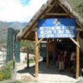 |
|
 Stairs Altitude: 8766 ft (2672 m) | |
|
 Salapunku This is the first archaeological inca site seen during the Trek. It is located at the right bank of the Urubamba river. | 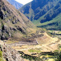 |
|
Q'hanamarca Archaeological inca site. | 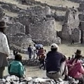 |
|
Ñustajispana This site is decently called sometimes Ñustahispana that, in quechua, means the Spanish princess; but its real name means the princess that urinates, to remember that even the nobility was constitued by human beings. | |
|
Llaqtapata Altitude: 9022 ft (2750 m) In the km 3, will discover Llaqtapata which, in quechua, means the town on hillside. These ruins, constitued by a village and farming terraces, are located on the banks of the Cusichaca River. | 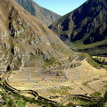 |
|
 Qoriwayrachina Altitude: 8202 ft (2500 m) Railway station at km 88. It is another departure point of the Inca Trail. | |
|
 Qoriwayrachina Altitude: 8202 ft (2500 m) Bridge in Qoriwayrachina, at km 88, crossing the Urubamba river. | 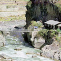 |
|
Miskay Altitude: 8727 ft (2660 m) Archaeological inca site. | |
|
 Miskay Altitude: 8727 ft (2660 m) Lunch at Miskay | |
|
Willkarakay Archaeological inca site. | 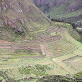 |
|
Ruines Archaeological inca site. | |
|
Tablachaka Altitude: 9186 ft (2800 m) | |
|
Urkapata Archaeological inca site. | |
|
 First Night Camp out Altitude: 11122 ft (3390 m) It's the Wayllabamba camp. | 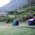 |
|
Stairs in Wayllabamba | 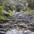 |
|
Yuncachimpa Altitude: 10696 ft (3260 m) The Yuncachimpa camp is often used to spend the first night. | |
|
Paucarcancha Altitude: 10515 ft (3205 m) Archaeological inca site, located at the confluence of the Pampacahua and Keska valleys. | 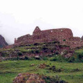 |
|
Coralpunku Altitude: 12139 ft (3700 m) | |
|
Llulluchapampa Altitude: 12467 ft (3800 m) |  |
|
Warmiwañusca Altitude: 13858 ft (4224 m) This is the highest point in the Inca Trail. It's not rare that it snows there and, after passing this point, weather and vegetation correspond to the high forest of Cusco. |  |
|
Stairs Altitude: 12008 ft (3660 m) | |
|
2nd Night Campsite Altitude: 11952 ft (3643 m) It's the Pacamayo camp, located at the bottom of the valley, where you will spend the second night. | 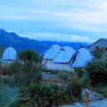 |
|
 Laguna Saqtaycocha Altitude: 13976 ft (4260 m) Magnificent lagoon, with resident ducks and geese. | 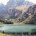 |
|
Runkuraqay Tambo Altitude: 12874 ft (3924 m) At the km 24, in the Pacaymayo valley, is located Tambo Inca, a semi-circular ovoidal building. | 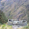 |
|
 Tunnel | |
|
Laguna Cochapata | 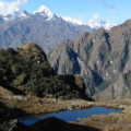 |
|
Abra Runkurakay Altitude: 12874 ft (3924 m) These are the ruins of Abra Runkurakay which are also the pass. |  |
|
Laguna Yanacocha Altitude: 13976 ft (4260 m) Yanacocha means in quechua the black lagoon. | 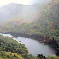 |
|
Sayaqmarka Altitude: 11926 ft (3635 m) At km 28 we find this building in labyrinth shape. The access is through stone stairs on the hillside. Once on top, you can admire the panoramic view of the hole Aobamba valley and the permanent snows of the Pumasillo glacier. | 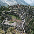 |
|
Paqaymayu Altitude: 11729 ft (3575 m) Lunch at Paqaymayu | |
|
Samana | |
|
Tunnel Altitude: 11962 ft (3646 m) | |
|
Phuyupatamarka Altitude: 11745 ft (3580 m) Located at the km 32, Phuyupatamarka means Town over the clouds in quechua. Overhanging the Urubamba valley, it is almost permanently surrounded by clouds. | 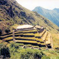 |
|
Tunnel Altitude: 10751 ft (3277 m) | 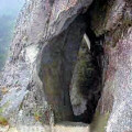 |
|
Wiñawayna Altitude: 8694 ft (2650 m) Located at km 39, Wiñawayna means forever young in quechua. | 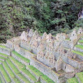 |
|
Last Night Camp out Altitude: 9101 ft (2774 m) The Winawayana camp is used for the last night of the Trek. | 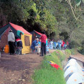 |
|
Intipata Altitude: 9350 ft (2850 m) Archaeological inca site. | 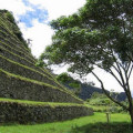 |
|
Choquesuysuy Altitude: 7037 ft (2145 m) Archaeological inca site. | 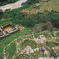 |
|
Chachabamba Altitude: 7123 ft (2171 m) Archaeological inca site. | 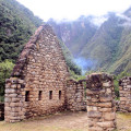 |
|
Km. 104 Altitude: 7057 ft (2151 m) The km 104 is the departure point of the 2-day Trek, the short version of the Inca Trail. | 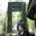 |
|
Intipunku Altitude: 8980 ft (2737 m) It's Intipunku, or the Sun Gate. |  |
|
Machu Picchu Altitude: 8038 ft (2450 m) Discovered in 1911, it is most known inca citadel in the world. It's justified and growing success draws attraction of numerous visitors the whole year long. | 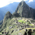 |
|
 Wayna Picchu Altitude: 8399 ft (2560 m) | 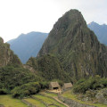 |
|
 Aguas Calientes Altitude: 6890 ft (2100 m) At the base of Machu Picchu is located the small village of Aguas Calientes. | 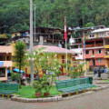 |
|
Railway station Railway station at the base of Machu Picchu. | 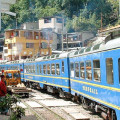 |
|
Nevado Salcantay Altitude: 20574 ft (6271 m) The highest mountain, Vilcabamba Cordillera | 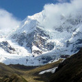 |
|
Veronica Glacier Altitude: 18642 ft (5682 m) Located on the other side of the valley, the glacier is visible during a part of the Trek. It's original name is Weqey Willka which meansSacred tear in quechua. | 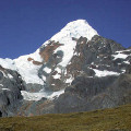 |
|
";
document.getElementById('sidecontent').innerHTML = html;
}
google.maps.event.addDomListener(window, 'load', initialize);